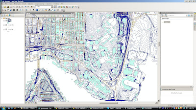

So we've started using GIS for composite mapping now and it is FUN.
As you can see from the picture there are ridiculous amounts of details and endless amounts of data! In a way its great. But in another way its somewhat difficult to pull out more abstract data directly and thats where the synthesis comes in. Our homework for this week's computer class is to take some GIS layers, import them into autocad, trim it and then manipulate to a small degree. Here's the issue. The GIS layers are so detailed and big that even the buff imacs at the U cannot process all the layers into a .dwg file export. So! We're forced to edit the layers individually in arcmap first then export. Bigger issue. The programs themselves are very expensive. GIS programs in particular. So when working at home we are accessing a remote applications server through the uw. When that application needs to retrieve data from my computer then process it back on campus it slows everything down to a 90 year old snail status. Thus we are required to upload anyfiles we need to that server's systems then use the program from there. Confused yet? I sure am. Until next time!
Real Estate Web Site Hosting


3 comments:
Hey I recently started a website (http://stuckinstudio.com) and I thought you might want to check it out. Let me know what you think.
Soon I will be making a links page to students blogs and portfolios and I will be sure to include this website on that list.
Good luck,
Pat McLoughlin
ooo :D
great website! will be sure to pass it around the studio :D
Post a Comment